+7 (812) 645-08-06
Surveying - Mapping
select brand


Total station with prism / reflectorless - max. 5 500 m, 1" - 5" | Trimble® SPSx30 series
For jobs which require the tightest precision and the fastest update rate available today, the patented Trimble technology...
Total station with prism / reflectorless - max. 5 500 m, 1" - 5" | Trimble® SPSx30 series
For jobs which require the tightest precision and the fastest update rate available today, the patented Trimble technology will ensure the best performance is achieved. Its MultiTrack technology enables it to lock on and track passive prisms for control measurements as well as active prism targets for grade control and paving applications.
Costly delays and subsequent rework is prevented. Increased productivity and faster results to grade are achieved by the faster speed.
Costly delays and subsequent rework is prevented. Increased productivity and faster results to grade are achieved by the faster speed.
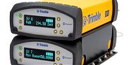
GPS receiver / GNSS / modular / for surveying - Trimble® SPS555H
The SPS555H Modular Add-on GNSS Receiver is designed to work in combination with the Trimble SPS855 GNSS...
GPS receiver / GNSS / modular / for surveying - Trimble® SPS555H
The SPS555H Modular Add-on GNSS Receiver is designed to work in combination with the Trimble SPS855 GNSS Modular Receiver and offers excellent positioning performance in marine construction applications. It is capable of tracking all known constellations regardless of working conditions and features satellite-based, internet and radio correction sources, a built-in radio unit and upgradable accuracy.
Satellite receiver / GPS / precision / reference - SPS series
The Trimble SPS351 DGPS/Beacon Receiver is ideally engineered for marine construction. It delivers sub-meter accuracy for an extended scope...
Satellite receiver / GPS / precision / reference - SPS series
The Trimble SPS351 DGPS/Beacon Receiver is ideally engineered for marine construction. It delivers sub-meter accuracy for an extended scope of marine industry operations. It utilizes the RTCM DGPS corrections either broadcastless by Beacon stations, from SBAS (satellite based augmentation systems) or through an outside radio or Internet connection from a local reference station. It is equipped with a Trimble EVEREST™ system that enhances outputs in a variety of ambient paths like applications on construction vessels and port building areas.

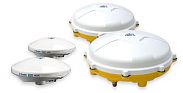
GNSS receiver / rugged / multi-channel / dual-frequency power - Trimble BX982
The Trimble BX982 has a dual antenna input that provides an edge over single GNSS systems in determining the position of the antenna proximal...
GNSS receiver / rugged / multi-channel / dual-frequency power - Trimble BX982
The Trimble BX982 has a dual antenna input that provides an edge over single GNSS systems in determining the position of the antenna proximal relative to the vehicle and the object, especially when there are low dynamics. It is a multi-channel, multi-frequency GNSS receiver for marine applications that necessitate heading and accuracy in centimeter-level. To augment a single input system, external sensors can be used, but there is a possibility to drift when static. With the use of the heading acquired from dual-antenna BX982 GNSS, these issues may be overcome.
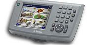
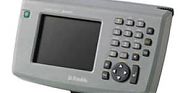
Field controller - TCU
The TCU is a clip on controller for flexibility in GNSS-based site positioning tasks. It is water and dust resistant and can withstand...
Field controller - TCU
The TCU is a clip on controller for flexibility in GNSS-based site positioning tasks. It is water and dust resistant and can withstand weather and jobsite conditions. The screen is bright and its daylight readable color display is clearly visible. The graphics are colored to speed up stakeout and data selections. It helps facilitate in navigating and positioning and improve management and quality assurance. 1GB memory capacity, a 64mb RAM and 400Mhz processor for faster processing of information are stored in the TCU.

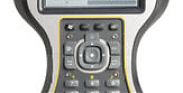
Touch screen handheld computer / GPS / field / for topographic data collection - ARM Cortex A8, 800 MHz, 256 MB, IP6X | Trimble® TSC3®
Optimized for Trimble Access field software
Fully-integrated Camera, Compass,...
Touch screen handheld computer / GPS / field / for topographic data collection - ARM Cortex A8, 800 MHz, 256 MB, IP6X | Trimble® TSC3®
Optimized for Trimble Access field software
Fully-integrated Camera, Compass, and communications
QWERTY or ABCD alphanumeric keypad
Internal GPS makes photo-geotagging easy
Large and high resolution, full VGA touch screen display improves readability
Improved collaboration and control through constant connectivity
Fully-integrated Camera, Compass, and communications
QWERTY or ABCD alphanumeric keypad
Internal GPS makes photo-geotagging easy
Large and high resolution, full VGA touch screen display improves readability
Improved collaboration and control through constant connectivity
Wireless handheld computer / field / heavy-duty / for topographic data collection - CU
Enhanced for Trimble Entry discipline application
Home windows Inlaid CE 6. R3 platform
completely...
Home windows Inlaid CE 6. R3 platform
completely...
Wireless handheld computer / field / heavy-duty / for topographic data collection - CU
Enhanced for Trimble Entry discipline application
Home windows Inlaid CE 6. R3 platform
completely...
Home windows Inlaid CE 6. R3 platform
completely...
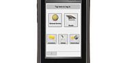
All-in-one handheld computer / field / for topographic data collection - scCustomerLogin
The slate controller of Timble is an all-in-one device that is capable of offering...
All-in-one handheld computer / field / for topographic data collection - scCustomerLogin
The slate controller of Timble is an all-in-one device that is capable of offering both data collection and smartphone expertise. Trimble's slate controller comes in a recognizable and customary structure due to its smartphone form factor design. It has a strong Gorilla Glass and touch display with 4.3 in capacitive.
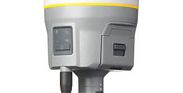
Surveying system GNSS - Trimble R10
The Trimble R10 GNSS System is the leading HD-GNSS production engine. It features a SurePointTM design for accurate position record, even with a 15°...
Surveying system GNSS - Trimble R10
The Trimble R10 GNSS System is the leading HD-GNSS production engine. It features a SurePointTM design for accurate position record, even with a 15°...

Surveying system GNSS - 220 channel, IP67 | Trimble® R8
The R8 GNSS System, manufactured by Trimble, is a surveying device that features a Trimble 360 Receiver...
Surveying system GNSS - 220 channel, IP67 | Trimble® R8
The R8 GNSS System, manufactured by Trimble, is a surveying device that features a Trimble 360 Receiver Technology. This technology is capable of supporting signals from all existing and planned GNSS constellations and augmentation systems. In addition, it offers a superior 440 channel solution with versatile wireless communication options to provide connections to the controller.


Measuring wheel - 0993714004
This model of measuring wheels by Werth is capable of a maximum measuring...
Measuring wheel - 0993714004
This model of measuring wheels by Werth is capable of a maximum measuring range of 9099.99 m, and has a 0.05% measuring accuracy.
The wheel is constructed with die casted aluminum material. The model weighs in at 3900 g, and has a wheel diameter of 318.5 mm and a 1 m circumference.
The wheel is constructed with die casted aluminum material. The model weighs in at 3900 g, and has a wheel diameter of 318.5 mm and a 1 m circumference.